Eungella National Park – Long Excursion, 5 to 13 May, 2026 (8 nights)
DATE & TIME
- 5 May 2026
- 9am Regional Botanic Gardens (first event long excursion)
- This event commences in:
EXCURSION LEADER
- Delma Clifton & Tom Wixted (Contact details will be provided after on-line registration)
LOCATION
- Mackay Regional Botanic Gardens (first day event)
Background
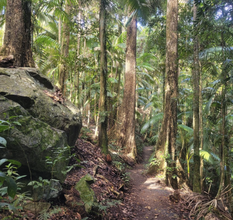
Eungella NP, situated 80km west of Mackay and 690m above sea level, is one of Queensland’s most ecologically diverse regions due to being the border between subtropical and tropical rainforest. Gazetted in 1936, it contains about 860 plant species and numerous animals including Eungella dayfrog, Eungella spiny cray, Eungella honeyeater, and a healthy population of platypus. Eungella is an aboriginal word meaning ‘land of clouds’ because it is often shrouded in mist. Average rainfall is 2240mm and some scientists have suggested that it should be classified as cloud forest. In May, average temperatures range from minimum 12C to maximum 23C.
Travelling
Please make your own way to Mackay by May 4, 2026.
Participants will meet at the Regional Botanic Gardens, Lagoon St, Mackay, at 9am Tuesday, May 5 for a guided tour.
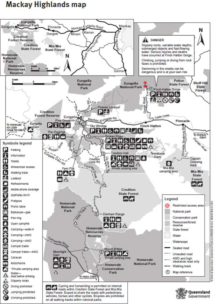
We will then travel to the campsite at Crediton Hall, Eungella after lunch. See Mackay Highlands Map.
Below are some suggestions for free/cheap camps along the Bruce Hwy. Also note that many hotels in small towns (often just off the highway) also encourage overnight campers.
- Howard RV Stop, Steley St;
- Childers RV Stop 5 Crescent St;
- Boyne River Rest Area, Benaraby;
- Calliope River;
- Waverley Creek, Bruce Hwy;
- St Lawrence Showgrounds (birdwatching);
- Barracrab Van Park, Clairview (birdwatching);
- Carmilla Beach.
Recommended campsites for May 4 in Mackay area: Armstrongs Beach Van Park, Blacks Beach Van Park (Big 4).
Accommodation
Camping at Crediton Hall with toilets, and a covered area. There is no potable water at Crediton Hall. Creek water can be collected for washing. Potable water can be sourced from Eungella Hall.
Tents may be erected under the covered area.
Camping fees: $20 pn powered site (8 sites available, assigned to first to register); $5 pn unpowered; payable to Crediton Hall Committee on arrival.
Cabins are available at Broken River Mountain Resort (10km), Eungella Chalet and Mountain Edge Escape (15km) for approximately $55 per night group share (based on full cabin). Make own arrangements and booking.
Equipment
Please bring all camping and hiking equipment.
Potable water – there is no treated water available at Crediton Hall; water containers can be refilled at Eungella Hall; creek water is available for washing.
Each person should carry a small first aid kit, including treatment for leeches.
Eungella can be very cold and is often wet, so extra clothing is essential.
Handheld radios, if available, will be useful as mobile phone coverage is patchy.
Services
Food: Platypus Café, Broken River (Fri, Sat, Sun, 9am – 2pm, 10km); Eungella Chalet (15km); Finch Hatton Pub (33km).
Groceries: Woolworths, Marian (68km); Valley Rural Services, Finch Hatton (limited – 36km), Eungella Chalet (bread milk, firewood – 15km).
Dump Point: Mirani (59km)
Closest Fuel: Valley Rural Services, Finch Hatton (36km)
Potable water and hot showers: Eungella Hall (16km)
Registration
Participants who are camping must be QNC members for insurance purposes. Details of membership are available at Membership QNC
Register for the camp via the website (qnc.org.au) by clicking on the excursion name and completing all fields. Note if you want a powered camp site mention this in the comments section of the online form.
Email registration is available to those not familiar with using a website.
- Email the Excursion Secretary at excursion@qnc.org.au. In the email, please include:
- Excursion name in subject line, and
- Each participants’ full name/s, mobile phone number, email address, and emergency contact name and mobile number
- Note if you want a powered camp site mention is in the email
Daily participants can join as Guests. Please signal your intention to join, in advance, by sms to the excursion leaders/coordinators.
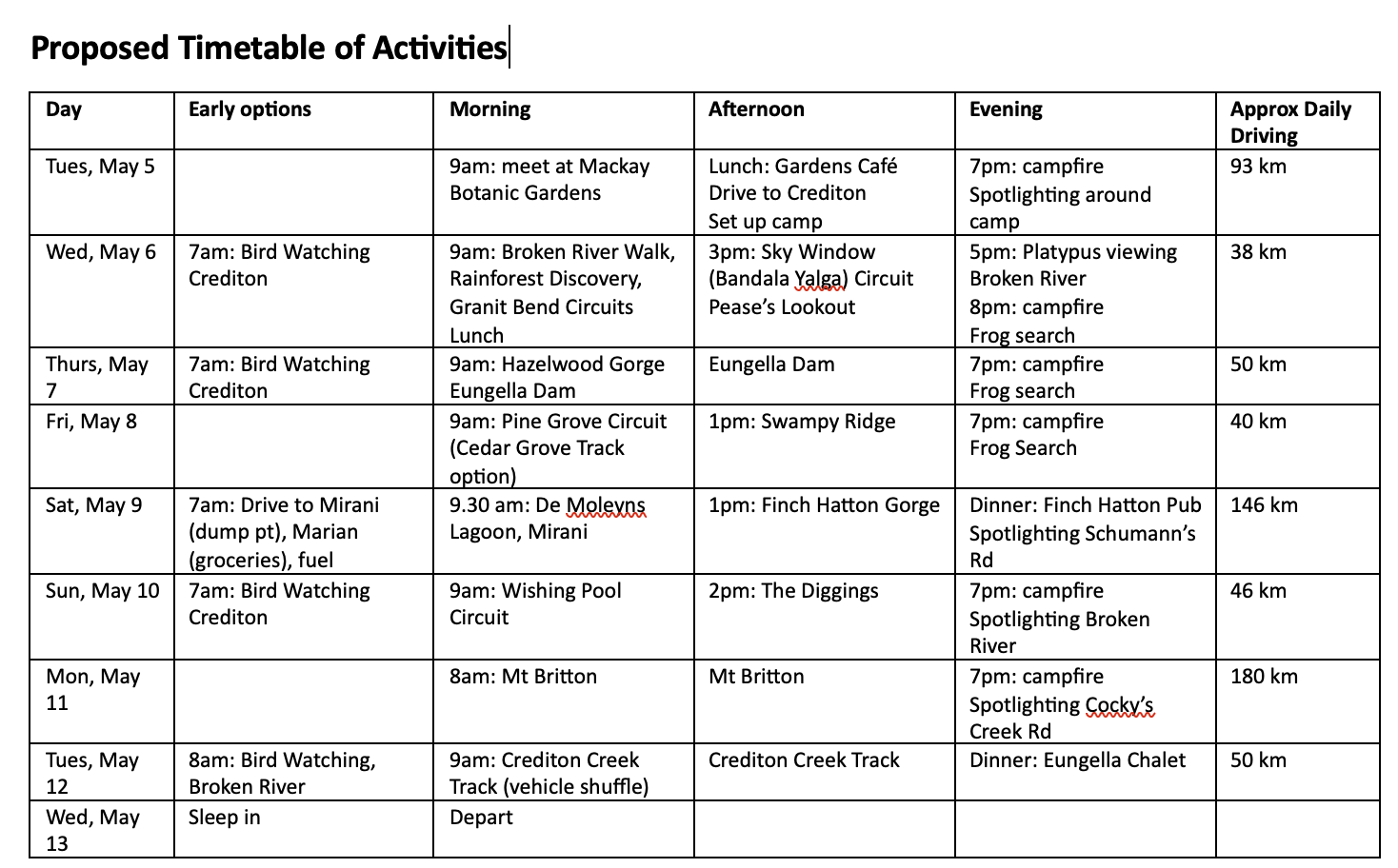
See the Timetable below for a proposed list of activites.
Here’s some additional information to get the most out of the Long Excursion. Right Click to save the image or download the URL to your device to created, then print or keep on device as needed:
- The Activity Timetable can be found here: Proposed Timetable of Activities
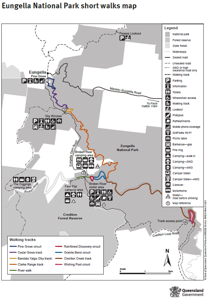
- A Eungella National Park Short Walk Map can be found here: Eungella Short Walks
- Details on all the walks in the National Park can be found here: Guide to Walks Eungella
- Highlands Map given earlier to Navigate to Eungella NP Camping: Mackay Highlands Map
Harry Hines has provided academic papers on the environment, as well as some species we should encounter during the excursion. Links to the articles are provided below:
- Hines-et-al-2020-Extent-severity-Mackay-highlands-2018-wildfires-and-impacts-natural-values-particularly-mesic-forests-of-Eungella-Crediton-Proc-Royal-Soc-Qld.pdf
- Meyer-et-al-2020-An-update-on-the-status-of-wet-forest-stream-dwelling-frogs-of-the-Eungella-region-Proc-Royal-Soc-Qld.pdf
- Scott-et-al-2024-A-targeted-study-to-determine-the-conservation-status-of-a-Data-Deficient-montane-lizard-Saproscincus-eungellensis-Pacific-Conservation-Biology.pdf
- Price-et-al-2025-Systematic-evaluation-of-molecular-genetic-morphological-and-acoustic-variation-reveals-three-species-in-the-Litoria-revelata-complex-Zootaxa-low-res.pdf
- Farquhar-et-al-2025-Microhabitat-preferences-climate-vulnerability-and-conservation-status-of-the-high-elevation-orange-speckled-forest-skink-Tumbunascincus-luteilateralis-Austral-Ecology.pdf